Monday, June 13

A Travel beyond the Himalayas: Mustang #4!

ofqf lxdfn kfl/sf] M d':tf¨ efu —­$

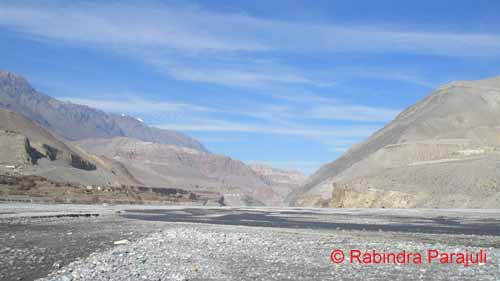
Ranipauwa, the only town of Muktinath, is about 45 minutes walk from the Jharkot. The trail, along with the land settings looks perfect: wide enough and neither plain nor steeply uphill. The landscape is rather mild but with very rough terrain.  No greenery around. That may be because of the season. People said it gets a bit greener during summer though there are no trees. Only few adaptive scrubs and herbaceous species grow and bloom when the area receives rain. Rainfall is very scanty. Mustang is one of those areas which receive extremely low rainfall. As I already mentioned on previous post, this is mainly due to the monsoon shaded by Annapurna-Dhaulagiri Massif. One of greatest naturalists, Adam Stainton classified this valley as Inner Himalayan Valley. In his book ‘The Forest of Nepal’, he mentioned that Mustang has similar vegetation to Tibet because of the physiographic and climatic similarity. The only few woody species found modifies their habit into compact and dwarf spiny form. Such life form is called Cushion, which is the best life form to cope the environmental (especially extreme radiation, aridity, temperature and wind) as well as biotic (browsing by Yaks, Naks, Chauries, Horses, Sheeps and Goats etc.) severity. These cushion species are an integral components of trans-Himalayan vegetation.

Landscape of Mustang with Mt. Dhaulagiri on distance
 As I approached Ranipauwa, I checked quite a few hotels but couldn’t see my research colleague. I didn’t have any alternative, so opted to go find him around Muktinath Temple Complex. 
Ranipauwa Town, Muktinath Mustang
 It takes about 15 minutes from Ranipauwa to Muktinath temple. The trail is somewhat uphill but not really hard. I was alone and climbing up towards main gate of the temple. Because of being in high altitude area it was hard to walk, and had to drink water quite frequently with sufficient rest. The souvenir shops on both side of trail were trying to persuade me to buy their stuffs. They were getting excited when I started looking at their shops. But their excitement didn’t last long because I only had bare promises. As of many visitors, who just see their souvenirs, I also didn’t buy. I looked at their shop because there were some really interesting items like ammonites, very thick and attractive woolen scarf, socks etc. They jack up price quite interestingly. I asked a lady who had the largest shop on right side of trail, about the way of fixing prices and percentage they save as profit. 
The souvenir shops and Close up view of the town.
Firstly she denied talking but later after a long conversation on other aspects of her life, she revealed that they fix price observing the costumer. She told that she sometimes hike up the price even up to 200%. It largely based on how much time costumer spent looking her stuffs. For those who looks souvenirs for longer, play with those and gets smaller items, she charges more money. But, that visitor who goes for quick selection gets quite a good discount. However, she argued that she has never charged inexplicably. It is interesting to note that all the souvenir shops were ran by women. Further, they are not so aware about the skin problems they might face because of the intense solar radiation and the dust wind blows, and strikes their skin every seconds. Even if they know they can’t quite the shop – one of the major sources of income for their family to sustain and to educate their kids. Though they are quite adaptive to physical surrounding, they may not be able to tolerate cancer causing solar radiation! Above all they are enjoying, which is great :)
See the people looking at one of the souvenir shops. (sorry for poor quality pic.!
But I was walking slowly and taking longer than I was supposed to. I was planning to wait Gabe outside the complex because I didn’t want to visit the temple that day! It is believed that before entering into Hindu religious complexes, one should be sacred. According to mythology, it is considered to be sacred/ pure if one takes shower and changes clean clothes. Although I showered last evening and was pretty clean, I was not culturally pure because I didn’t washed my body on same day. So, as an inborn Hindu [I’m a believer and do believe on existence of God but just SINGLE. I think, The God for all religion is same (and just ONE) but the way of perceiving him are different so there are many religions around the world], I was not willing to enter into temple complex when I was (so called) impure.

The Holy Muktinath Temple, Mustang

Monday, April 18

A Travel Beyond the Himalayas: Mustang # 3!

d':tf¨ efu —­#

A view of Himalayas as seen from the Pokhara Airport


I got to capture these stunning Himalayas from Plane

hf]d;f]d} ahf/df !@ ah] xfjf ;// .
P xh'/ 3/ xfd|f] kf]v/f, cEfm} ;Dd ef5}g 3/af/ ..
(Jomsome, air blows 12.00 noon;
Hey, we are from Pokhara and still unmarried!!) 

This is a rhyme of one famous Nepali song (by Nepathya) echoing on and striking me when I was about to step down from Sita Airlines’ Twin Otter (spell?) plane for the first time in Jomsome Bazzar. As in song, it was extremely windy. The wind blowing from south to north was such a strong that it was very difficult for everyone to handle their bags and move smoothlyL. But walking along the air current was super easy and effortless!
Landed Safely :)... Jomsome Airport and Mt. Nilgiri on the background
The journey was highly remarkable for me! I had to struggle to fly. Due to the fluctuating weather flights were cancelled for two days. Even in third day weather was not so good but the captain dared to fly, and thanks GOD for safe landingJ. That was the only flight taken that day. If I would not have gotten chance to fly on that plane I would have to wait for another day. So, I must thank a guy (I’m sorry, I forget his name) from SITA Air who was highly generous to provide me room on first flight even there was a long queue of foreign tourist who were paying way more in US$ for the ticket.

See the arid landscapes of Mustang and a suspension bridge above  Kaligandaki River
Although very dry and arid, landscapes were carved in such a way that everyone could easily lost within the beauty of Mustang. And, I was super excited to travel beyond the Himalayas. The only problem I had was being late by 2 days to conduct research. My research partner Mr. Gabe Stutman (from Washington DC, USA), who was already in Muktinath temple, was counting every minute for my arrival. And, It is totally understandable that how terrible time everyone finds to wait someone not even for a couple of hours but for three days! I am sorry my friend (d]/f] ;fyL u]j dnfO{ dfkm ug'{xf];\ .) ! 

Though it was super windy I decided to leave for Jharkot where everyone was waiting me. We had a team of 8 students (4 Nepali and 4 Americans) from CNSP (Cornell Nepal Study Program) looking at four different aspects in Mustang. As a part of regular courses of CNSP our American friends were there for their research and we (Nepali students) were assisting them.

The Jharkot Village
When I got into Hotel Plazza in Jharkot around 6:00 pm I was completely exhausted. I didn’t see anything on the store but just the Fanta! Wow J I didn’t have to wait for second round to finish half liter fanta. Now I could see who were there; almost all except Paul and Gabe! I came to know that Paul is staying with Amchi and Gabe is in Ranipauwa - Muktinath.
 
Winter season; Mustang region; evening time; very tired; how would you feel if you take shower using freezing water? Though shivering with almost frozen fingers, I was feeling refreshed! Cold but clean! Great time for coffee.

See few more snaps on the way to Jharkot:

Mustang valley: Kaligandaki River gorge

Plants coping with aridity
Salix were the only trees I saw with leaves

Sunday, April 3

A Travel Beyond the Himalayas: Mustang # 2!

Major Routes:
Mustang is one of the major tourist destinations of Nepal. Many people visit the area not only to experience local culture and enjoy scenic beauty but also to understand the religious mutualism – which is being exemplified by the Holy Muktinath Temple. Thousands of National as well as foreign (mainly Indians) Hindu people visits this temple as a pilgrim. There are many things to talk about the Mythology, beliefs and other important aspects of Mustang and Muktinath Temple as well. Which I think is better if it is dealt details of each site separately. So, for now let’s starts with Major Route to Mustang in an order of shortest to Longest:-
Map showing the Route 1: the green line
 Route 1: Pokhara – Jomsome – Muktinath (the shortest one!)
Area: Mustang, Nepal
Type of tour: Eco-cultural/Pilgrimage
Difficulty: Easy
Hotel Facility: Available; Average - Standard
Trip Costs: US$50 - 150 per day per persons (foreign tourists) + Flight charge: US$ 160 - 200
NRs.1500 – NRs.3500 per day per persons (national tourists) + Flight Charge: NRs. 4000/7000
Maximum Elevation: 3850 meter average sea level
Season: Almost every season
Duration: 4 days
Day 1: Fly from Pokhara to Jomsom (15 minutes flight) and trek to Kegbeni (2 hrs.)
Day 2: Kagbeni to Muktinath (4 hrs.)
Day 3: Muktinath to Jomsom (5 hrs.)
Day 4: Fly from Jomsom to Pokhara (15 minutes flight)

Route 2: Pokhara – Beni – Tatopani – Jomsome – Muktinath
Area: Mustang, Nepal
Type of tour: Eco-cultural/Geographical/Pilgrimage
Difficulty: Medium
Hotel Facility: Available; Average - Standard
Trip Costs: US$50 - 150 per day per persons (foreign tourists) + Flight charge: US$ 80 - 100
NRs.1500 – NRs.3500 per day per persons (national tourists) + Flight Charge: NRs. 2000/3500
Maximum Elevation: 3850 meter average sea level
Season: September – October
Duration: 8 days
Day 1: Drive from Pokhara to Beni
Day 2: Beni to Tatopani
Day 3: Tatopani to Kalopani
Day 4: Kalopani to Jomsom via. Marpha (the delightful apple kingdom of Nepal)
Day 5: Jomsom to Kagbeni
Day 6: Kagbeni to Muktinath
Day 7: Muktinath to Jomsom
Day 8: Fly from Jomsom to Pokhara
Map Showing Route 2 (the green line) and Route 3 (the red + green then after): I apologies for poor quality oblique map!
Route 3: Pokhara – Ghorepani – Tatopani – Jomsome – Muktinath
Area: Mustang, Nepal
Type of tour: Eco-cultural/Pilgrimage
Difficulty: Strenuous
Hotel Facility: Available; Average - Standard
Trip Costs: US$50 - 150 per day per persons (foreign tourists) + Flight charge: US$ 80 - 100
NRs.1500 – 3500 per day per persons (national tourists) + Flight Charge: NRs. 2000/3500
Maximum Elevation: 3850 meter average sea level
Season: March – April and September – October
Duration: 10 days
Day 1: Drive from Pokhara to Birethanti
Day 2: Birethanti to Ulleri
Day 3: Ulleri to Ghorapani (to Pun Hill as well)
Day 4: Ghorapani to Tatopani
Day 5: Tatopani to Kalopani
Day 6: Kalopani to Jomsom
Day 7: Jomsom to Kagbeni
Day 8: Kagbeni to Muktinath
Day 9: Muktinath to Jomsom
Day 10: Fly from Jomsom to Pokhara

Route 4: Pokhara – Dumre (Tanahu) – Besisahar (Lamjung) – Chame – Manang – Thorang Phedi – Thorang-La – Muktinath: The Annapurna Circuit trek - longest one! This takes 2 weeks to get back to Pokhara after a complete circle, but it is still worthy to enjoy the vastness of Himalayas.
Area: Manang and Mustang, Nepal
Type of tour: Ecological – Cultural – Geographical
Difficulty: Strenuous /Tough
Hotel Facility: Available; Average - Standard
Trip Costs: US$75 - 200 per day per persons (foreign tourists) + Flight charge: US$ 80 - 100
NRs.1500 – NRs.3500 per day per persons (national tourists) + Flight Charge: NRs. 2000/3500
Maximum Elevation: 5416 meter average sea level
Temperature: Goes below freezing during Thorang-La cross
Season: March – April and September – October
Duration: 10 days
Day 1: Drive from Pokhara to Beshisahar (5 hrs.)
Day 2: Beshisahar to Bahaundanda (5.75 hrs.)
Day 3: Bahaundanda to Jagat (4.5 hrs.)
Day 4: Jagat to Dharapani (5 hrs.)
Day 5: Dharapani to Chame (4.75 hrs.)
Day 6: Chame to Pisang (4. 5 hrs.)
Day 7: Pisang to Braga/Manang (3.5/4 hrs.)
Day 8: Manang Rest day (Hike to Icelake)
Day 9: Manang to Ledar (3.5 hrs.)
Day 10: Ledar to Thorangla Phedi/High Camp (3/4.5 hrs.)
Day 11: Thorangla Phedi/High Camp to Muktinath (8 to 10 hrs.)
Day 12: Muktinath to Kagbeni via Jhong (3 hrs.)
Day 13: Kagbeni to Jomsom (2 hrs.)
Day 14: Fly from Jomsom to Pokhara (15 minutes)

Thursday, March 24

A Travel Beyond the Himalayas: Mustang # 1!

General Information
Mustang, also called the “Himal Pariko Jilla (District beyond the Himalayas)”, lies north to the gigantic Annapurna-Dhaulagiri massif. People from low land called it as “Thak Khola”; meaning – the land of Thakalis (Gurung Communities). The region represents an extension of the Tibetan Platue and characterized by extremely dry climate. The Annapurna (8091m average sea level) and Dhaulagiri (8167 m asl) screens the summer monsoon, hence the rainfall is very scarce. 
Dhaulagiri range - a major summer monsoon barrier ; as seen towards south from the Jomsom (the HQ of Mustang)
Some people named the valley as a ‘desert of the Himalayas’. But ecologically it is being characterized as an ARID zone and the flora recognized as Tibetan elements. The vegetation is of the steppe type with domination of Caragana spp., Lonicera spp., Juniperus spp., Rosa spp. etc. Tree species are limited to only Populus and Salix. Apples tree are also found booming in private orchards.
A Landscape showing Cushion forming Caragana - Lonicera vegetation and Mt. Dhaulagiri on distant
Politically, traditionally and even culturally (I think) the whole Mustang valley is divided into 2 major regions; the Upper Mustang (popularly called the Lo-Manthang) and the Lower Mustang. Kaligandaki river is the only river-system originated from Mustang. The river is famous in Hindu religion because we can find Ammonites/Shaligram (one of the various forms of Lord Bishnu - the Protector).

A landscape of Mustang showing the gorge carved by Kaligandaki river ; taken on 21st of November.
Lo-manthang is the northern part of the Mustang extended towards north from Kagbeni up to the border of Chinese Autonomous Region – the Tibet. The area is designated as a restricted zone by the Department of Immigration, Government of Nepal. To my knowledge, it is because the area has its particular culture/traditions, has been ruling by the local King since centuries, and also because of being an open border area with Tibet. It is mandatory to have an especial entry permit to visit Lo-Manthang. The fee is quite a bit high. One person should pay at least US$ 500 to enter the area and this works for 10days. For each extra day need to pay US$ 50/day. The Department of Immigration only issues the permit. I haven’t yet been to Upper Mustang. I would love to go and will write in detail if I get chance to visit.
Kaligandaki River and the lower part of Lo-Manthang, where we can find Ammonites easily
It is much easier to trek on the Lower Mustang. But a permit is must for foreigners. The permit provisions are as: 
Permit Procedure and Regulations:
Entry Fee (Per Person) to visit Annapurna Conservation Area (ACA):
For SAARC Nationals: Nepali Rupees 200.
For other Nationals (other than SAARC countries): Nepali Rupees 2,000.
Note:
Entrance fee not required for children less than 10 years of age.
Trekkers visiting multiple Conservation Areas will require obtaining individual Entry Permits for each Conservation Area.
Two passport size photographs are required while applying for each Entry Permit.
Terms and Conditions:
This Entry Permit is valid for single entry only and is non refundable, non-transferable. The permit holder can enter the designated places within the Conservation Area.
Person entering the Conservation Area shall abide by the National Park and Wildlife Conservation Act, 2029 B.S. (1973) and the Regulations made under this Act.
This Entry Permit must be carried during the entire trip and should be shown if concerned personnel of the Conservation Area want to check it.
Entry permits to Annapurna Conservation Area (and Manaslu Conservation Area as well) will only be issued from the following Entry Permit Counters listed below. Entry Permits will not be issued from any check posts along the trekking routes of the Conservation Areas. Therefore, all are requested to obtain an Entry Permit before entering the Conservation Areas. However, under special circumstances, Entry Permit may be issued from the check posts along the trekking route upon a payment of 100% additional charge.
Entry Permits available at the following locations:
Kathmandu: Nepal Tourism Board , Bhrikutimandap, Kathmandu (for Annapurna & Manaslu)
Opening hours Sunday to Saturday except on public holidays in Kathmandu: 9 am – 5 pm
Pokhara: Nepal Tourism Board, Tourist Service Centre, Pardi Damside (for Annapurna only)
Opening hours Sunday to Saturday except on public holidays in Pokhara: 10 am – 5 pm
Download Entry Permit Application Forms:
For further information please contact:
NTNC, Kathmandu: info@ntnc.org.np
NTNC-ACAP, Pokhara: info@ntnc-acap.org.np


Source of permit procedures and regulations: http://www.ntnc.org.np/trekking-annapurna-and-manaslu-information-and-entry-permit-forms 

Saturday, March 12

#2. HIMALAYAS - The Beauty and Majesty: Facts

  1.  In Sanskrit HIMA = Snow and ALAYA = Abode; hence HIMALAYA = ‘the abode of snow’.
  2.  Though it is unusual to have such an amount of snow/ice accumulation in low latitude, the mountain are so high that the cold and rarefied air always adores their peaks so that the snow/ice respects and keeps on covering constantly.
  3.  Himalayas – the world’s tallest mountains – are the mountains in between Indus River on the west to the Barhmaputra River on the east, measuring approximately 2400 kilometers, with width variation from 160 – 240 kilometers.
  4. Himalayas cover about 0.4% of the Earth’s Space i.e. an area of 612021 square KM.
  5.  Himalayas, also called “the water towers”, are the origin of some major river systems like the Indus, the Sutlej, the Ganges, the Mahakali, the Karnali, the Gandaki, the Sapta Koshi, and the Burhmaputra – the source of fresh water for about 1/3rd of the world populations.
  6. Erosion is crucial in case of the Himalayas, not only in creation of antecedent rivers, but in the general formation of Himalayas.
  7. According to Bob Stoddard, if there wouldn’t be the wearing down of this gigantic earth wrinkle, the Himalayas would be much higher and growing at the rate of 8 – 10 centimeters annually.
  8.  He furthers argues that, the present rate of erosion is such that it takes a century for the mountains to increase in height even a few centimeters.
  9.  Erosion affects not only the height but also carves into steep peaks, narrow gorges, and the generally rugged topography that characterizes these young mountains.
  10. Himalayas are one of the most vulnerable areas of world due to climate change. Various studies suggest that warming in the Himalayas has been much greater than the global average of 0.74°C over the last 100 years.
  11. The Himalayas are characterized by high altitude, rich biodiversity and high endemism despite being environmentally severe.
  12. It is accepted that abiotic stresses increase with increased altitude in the Himalayas.
  13.  Many of the World's most sensitive ecosystems are in Mountain regions.
  14. Mountain ecosystems support 1/2 of the world's biological diversity and nearly half of the world's biodiversity Hotspots (Hassan et.al. 2005).
  15. Globalization, economic policies, increasing pressure on land and resources due to economic growth, land-use change, and change in population structure and lifestyle are some of the drivers of change that impact the mountain ecosystem and people.
  16. Global climate change acts an additional stressor to exacerbate the impact of other drivers of change (ICIMOD 2010).
  17. There are about 204 critical glacial lakes in Hindu-Kush Himalayan region that have a potential for bursting.

Friday, March 11

A Thrilling Journey into the Himalayas


Before jumping into my journeys and experiences in the Himalayas, although it may not be new for you, I am going to present a brief introduction of the Himalayas; especially the origin and evolution!

A View of Himalayas as seen from Phyuk Ri, Nuwakot

A quote, my favorite one, about the Himalayas by a famous Nepalese Geographer which, I always appreciate and adore:

“IT WOULD BE MORE REALISTIC TO CONSIDER MOUNTAINS AS DYNAMIC, CERTAINLY NOT FRAGILE”
Dr. Harka Gurung (2004).

#1. Himalayas: The Youngest Mountains in the World

Mt. Dhaulagiri Range as seen from just above Ghorepani, Myagdi
According to Bob Stoddard, Professor of Geography at the University of Nebraska-Linkon, US; the origin of the Himalayas dates backs some fifty million years ago when the two continental plates that form the cores of peninsular India (Gondwana land) and central Asia (Laurasia) began squeezing together. Previously these huge sections of earth surface were separated by shallow sea, which was receiving the eroded sands and muds that were being dumped into it by rivers emitting from the land masses. As the two continents moved together, they squeezed and buckled these relatively soft earth materials into gigantic folds. As these earth materials became pushed higher, they formed the ranges of mountains – now called the Himalayas. Actually this mountain-building process is still occurring as the mountains continue to rise each year.

Gauri Shanker Himalayan range with (Abeis tree on foreground) as seen in the evening from Kalinchowk temple, Dolakha; 28 October, 2010

The evidences are: one is the limestone beds that compose part of the highest mountains, such as Mt. Everest (Sagarmatha) because the origin of limestone was the former shallow sea. And these days those sedimentary rocks are way far from the sea level standing as a water tower. Next evidence: the fossils found on the slopes of the mountains (e.g. the Ammonites i.e. Saligram Sila found in Kaligandaki valley, Mustang, Nepal) indicate life that once existed in seas before the mountains arose. 

Thursday, February 24

Knowing Orchids Seriatim


# g. Satyrium nepalense D. Don


Habit: Herbaceous (terrestrial)
Family: Orchidaceae
Distribution: Pakistan to South West China, Nepal Himalayas
Altitude range: 1500 – 4000 m average sea level
Habitat: Subtropical to Alpine Meadows; growing open grassy slopes
Flowering: June - September
Reference(s): (Polunin & Stainton 1984)
Photo: Nagarkot, Central Nepal
*Polunin, O. & Stainton, A. (1984) Flowers of the Himalaya. U.K.: Oxford University Press.

Knowing Orchids Seriatim


# f. Pleione humilis (Smith) D. Don


Habit: Herbaceous
Family: Orchidaceae
Distribution: Central Nepal Himalayas to South East China, Burma
Altitude range: 2000 – 3000 m average sea level
Habitat: Temperate zones; growing on rocks and steep banks
Flowering: October - November
Reference(s): (Polunin & Stainton 1984)*
Photo: Olangchunggola, Kanchanjunga Conservation Area, Eastern Nepal. 
*Polunin, O. & Stainton, A. (1984) Flowers of the Himalaya. U.K.: Oxford University Press.

Knowing Orchids Seriatim


# e. Spiranthus sinensis (Pers.) Ames


Habit: Herbaceous (terrestrial)
Family: Orchidaceae
Distribution: Afganistan to South East China through Nepal Himalayas, Australia
Altitude range: 1000 – 4500 m average sea level
Habitat: Subtropical to Alpine Meadows; growing open slopes and cultivated areas
Flowering: April - August
Reference(s): (Polunin & Stainton 1984)*
Photo: Nagarkot, Central Nepal
* Polunin, O. & Stainton, A. (1984) Flowers of the Himalaya. U.K.: Oxford University Press.